

The vast expanse of the salt flat ("The Vanished Sea").
| “ | These harsh salt flats are two thousand metres below sea level. They're all that's left of the sparkling, clear blue waters of the Mediterranean.
|
” |
The Mediterranean Salt Flat is an extensive salt flat covering most of the Mediterranean Basin in 5 million AD. An extremely arid "salt desert" experiencing extreme temperatures, it was formed by a combination of continental drift and the dry ice age climate. The salt and its brine lakes are inhospitable, and most life in the Mediterranean are found on limestone karst plateaux, including animals and hardy, windblown plants.
Geography[]
| “ | ... it takes more than a change in climate to make the Mediterranean dry out. In five million years time, the geography of the Earth will have changed, when Africa will have pushed up against Europe and closed the Straits of Gibraltar.
|
” |
The Mediterranean Basin is a large depression in the Earth's crust, which reaches depths of more than 6,500 ft (2000 m) below sea level in places. During the Human era, it was filled with seawater from the Atlantic through the Straits of Gibraltar, sustaining the Mediterranean Sea. In 5 million AD, the sea is gone, and its former bed is a level salt flat stretching for around 2,000,000 square km (1,200,000 square m). Former islands such as Cyprus, Malta, Crete, and Majorca rise from the salt flat as steep mountains.[1]
Limestone karst pavements are common around the rim of the salt flat,[2] and around the island-mountains.[1] These plateaux are comprised of limestone blocks, called clints, which are scoured by intersecting fissures or crevices called grykes. The grykes range in size from a few centimetres to a few metres, but are generally narrow.[1] Soil and sediment blown from the continental interior accumulates in the bottoms of the grykes. Networks of subterranean caverns exist beneath the surface, some of which are accessible through grykes.[2]
Formation[]


The full extent of the salt flat ("The Vanished Sea").
The dessication of the Mediterranean was caused by both continental drift and the arid ice age climate. The initial impetus was the collision of Africa with Europe, which sealed the Straits of Gibraltar. This closed the connection between the Mediterranean and the Atlantic, depriving the former of its supply of water, and turning it into an inland sea. This was exacerbated by the dry ice age climate, which promotes both lower rainfall and lower sea levels.[1] Although the Mediterranean continued to receive fresh water from European and African rivers, this was not enough to replenish the water lost through evaporation, and the sea was gradually dessicated over around one million years.[2]
As the seawater evaporated, the amount of minerals in the water remained the same, increasing the overall mineral composition of the sea. This led to extensive limestone deposition on the seafloor. When the sea disappeared, these limestone pavements were exposed. Over millions of years, the fault lines on the limestone eroded into fissures, and finally grykes.[2]
Climate[]
| “ | Global temperatures are five or six degrees lower than they were in the Human era, and nowhere is this difference felt more than in the Mediterranean Basin. This once warm, sun-drenched region is now an arid, cold and rocky land.
|
” |


Hypersaline lakes exist on parts of the salt flat ("The Vanished Sea").
The salt flat is sometimes referred to as a "salt desert": its climate is extremely arid, with dry and dusty air. The only standing water on the salt flat gathers in hypersaline lakes and brine pools, which occur at the lowest elevations. The salinity levels of these water bodies is high enough to cause lethal salt poisoning. Rainfall occurs only rarely, and dissolves the surface layer of the salt flat into a "saline mush." However, even this liquid is quickly evaporated.[2]
The region experiences both extremes of temperature. The air is generally cold, as are the winds blown from the continental interiors.[3][2] However, the salt itself is heated by the sun, and can be scorchingly hot during the day: the heat reflected by the salt is up to 6°C warmer than anywhere in the Human era Mediterranean.[1]
Life[]
| “ | The whiteness is only alleviated by the odd smudge of red produced by the salt-loving bacteria. But there is something moving on the dazzling salt flat.
|
” |
Most plants and animals in the Mediterranean are found on the karst, as the salt flat itself supports very little life. Halophilic↗ bacteria and algae, which thrive only in hypersaline environments, exist both on the surface of the salt and in the hypersaline lakes, staining the salt red.[2]
Flora[]
Some grasses are able to grow on the shores of the hypersaline lakes.[1] On the karst, the presence of soil in the grykes allows plants, including hazel trees, to take root, although tree growth is stunted. Plant life is relatively rare on the edges of the karst, near the salt, but is more common at higher elevations. During the spring, vegetation is relatively abundant.[2]
Fauna[]

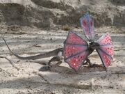
One of the only animals which can survive on the salt is the cryptile.
Very few animals can survive on the salt flat. Specialised brineflies are the only animals inhabiting the lakes and brine pools, where they feed on the halophilic bacteria and algae. These flies are the main food source for the cryptile lizard, the only vertebrate existing on the salt.[1]

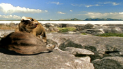
The gryken is well-adapted to hunting on the karst ("The Vanished Sea").
All other animals in the Mediterranean are restricted to the karst pavements. The largest is the scrofa,[4] a very small, omnivorous wild pig which is nimble enough to safely traverse the clints. Predators are more common in the uplands, including birds of prey,[2] and the gryken, a specialised inhabitant of the grykes and a top predator of the Mediterranean.
Gallery[]
")
")
")
")
")
Behind the scenes[]
In "The Vanished Sea," the limestone karst plateaux on the salt flat were filmed at Ingleborough National Nature Reserve, which is noted for its "great expanse of limestone pavement," in the United Kingdom. The real limestone plateaux there are known as "White Scars" and "Twistleton Scars".
List of appearances[]
- The Future Is Wild
- 1x01. Welcome to the Future
- 1x03. The Vanished Sea
- The Future Is Wild (US) (cameo)
- The Future Is Wild: A Natural History of the Future
- The Wild World of the Future
- The Future Is Wild (fulldome show)
- The Future Is Wild: The Living Book
Notes[]
- The Mediterranean Salt Flat and the North American Desert are the only ecoregions which, alongside their biotas, have never appeared in any The Future Is Wild spinoffs. The manga adaptation and the animated series depict all the other regions and organisms between them.
- The Mediterranean Basin faced a similar crisis 5 million years ago. During the Messinian salinity crisis↗ at the end of the Miocene, the Strait of Gibraltar was sealed, and the Mediterranean was almost completely dessicated. This was resolved by the Early Pliocene Zanclean flood↗.
- The Mediterranean Salt Flat also resembles an extreme form of Atlantropa↗, a proposed engineering project. However, Atlantropa would have been created by human activity rather than plate tectonics, and would have involved the flooding of part of Africa.
In other languages[]
| Language | Name | Translation |
|---|---|---|
| French | Bassin Méditerranéen | "Mediterranean Basin" |
| Japanese | Chichūkai bonchi (地中海盆地) | "Mediterranean Basin" |
References[]
- ↑ 1.0 1.1 1.2 1.3 1.4 1.5 1.6 The Future Is Wild: The Vanished Sea (EP03)
- ↑ 2.0 2.1 2.2 2.3 2.4 2.5 2.6 2.7 2.8 Dixon, Dougal & Adams, John (2002) The Future Is Wild: A Natural History of the Future, Firefly Books, ISBN 978-1552977231
- ↑ Pye, Claire (2003) The Wild World of the Future, Firefly Books, ISBN 978-1552977255
- ↑ Dixon, Dougal & Adams, Joanna (2014) The Future Is Wild: The Living Book, The Future is Wild Australia Pty Ltd.
[]
| |||||||||||